
The debate over one of the most controversial elements of Baltimore’s future Harborplace is about to shift out of neutral.
On Thursday, Baltimore’s planning commission will hear from city leaders and residents about the proposal to close portions of Pratt, Light and Calvert Streets as part of a realignment of the road network surrounding the Inner Harbor.
Local officials and developer P. David Bramble, whose MCB Real Estate is leading an effort to remake Harborplace, have proposed eliminating the Light Street slip lane or “spur” and reducing the size of the road network to prioritize pedestrian access and walkability over vehicle traffic through the heart of the city.
But that grandiose vision runs counter to the area’s current reality as a high-traffic corridor in a city that offers few reliable options, beyond a car, for getting around. The idea, much like Bramble’s vision for Harborplace which includes high-rises filled with luxury apartments and offices, has sparked fierce debates online and even in Baltimore Circuit Court.
Now it’s coming to a head as city leaders decide whether to make it a reality.
Councilman Ryan Dorsey, who will lead the council’s yet-to-be-scheduled discussion of the proposal once the planning commission weighs in, said the conversation is far broader than how cars will crisscross the city’s downtown.
Read More
“Baltimore has been prioritizing throughput of traffic over the welfare of the immediate surrounding area since the B&O Railroad ran a train straight down Pratt Street,” Dorsey said. “There’s nothing more ingrained in our transportation environment.”
“My concern isn’t where all those cars go,” he added. “It’s how the city can possibly thrive if we continue to make those cars our priority in decision making.”
The matter of where all those cars will go, however, is of great concern to some. Letters of opposition have been accumulating in advance of Thursday’s hearing. Writers lamented what the plan will do to traffic and the quality of life for residents who live along alternative routes.

“How can you condemn and close well-traveled city streets without a viable alternative for the people that drive those streets on a daily basis?” wrote Beth Braun, a Butchers Hill resident.
Before the new street plan can go into effect, it requires approval from the City Council, first in committee and then by voting as a whole. Dorsey said he will schedule hearings once they are requested by Baltimore Mayor Brandon Scott’s administration.
It’s unclear when work could begin once the city approves the plans, or if it’s contingent on Harborplace redevelopment advancing.
Pratt Street has long been a major thoroughfare, even before the twin Harborplace pavilions were built in the 1970s. The street’s current traffic pattern was borne of a grassroots effort to stop the construction of an east-west expressway across the city. That expressway would have connected Interstate 70 with I-83 and I-95, continuing to East Baltimore.
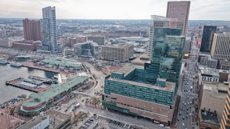
In lieu of a highway, the spur operates as a chute for drivers as they pass through downtown. Half of its four lanes zip northward onto Calvert Street, while the other half shoot eastward on Pratt Street.
Pratt Street shoulders the burden of Baltimore’s west-to-east traffic. Around 20,000 cars travel the street between Martin Luther King Jr. Boulevard and President Street on a given workday, according to data from the State Highway Administration. That’s more than other west-to-east downtown roads like Orleans Street and North Avenue.
It’s also one of the most dangerous streets in Baltimore for pedestrians, as is Light Street. They’re both in the city’s top tier of the High Injury Network, which grades streets based on crashes and resulting injuries, including to cyclists and pedestrians. The two roads also hug one of the most pedestrian-centered places in the city, the harbor promenade.
The system is the product of a time when city planners across the nation saw personal vehicles and highway construction as a path to urban renewal. Baltimore’s street grid has changed little since.
“Every city in America that is moving forward is resetting those priorities,” said Peter Park, a former planning director for Milwaukee and Denver who now works with cities as a consultant on land use, zoning reform and highway removal.
Successful urban environments with amenities like cultural institutions, walkable retail areas and natural third spaces will always have congestion, Park said. When he sees a traffic study for an urban area indicating low congestion levels, he added, “it tells me that there is nothing happening in the downtown.”
A study of Baltimore’s downtown conducted by the Traffic Group in 2023 found that almost half of the cars going east on Pratt Street eventually head north on Interstate 83. For comparison, 35% turn right on President Street and just 19% continue east.
The removal of a lane on Pratt Street would likely push some drivers to travel north on Charles Street or on a newly two-way Light Street and cross the city on Baltimore Street, the study found. Some areas of Baltimore Street, like the 500 block next to police headquarters, have just one lane of traffic.
“It is hopeful that with proper wayfinding plus an educational campaign, some commuters will elect to use MLK Boulevard or other routes to ultimately reach northbound I-83,” the study said.
The study also found that the proposed changes will lengthen commutes. The study assumed an 8-14% increase in commute times throughout downtown was “acceptable.”
“There is no question that some motorists will be inconvenienced as a result of the changes to eastbound Pratt Street and that will result in changes to other northbound, southbound, eastbound and westbound streets in downtown Baltimore,” the study said. “These changes will result in Baltimore becoming an incredibly better place to live, work and shop.”
The city’s transportation department indicated in early 2024 that it would conduct its own traffic analysis of the area separate from The Traffic Group study. Department officials have not provided a copy of any such analysis to The Banner, nor responded to a request to interview interim director Berke Attila.
Eleanor Carey, who has lived downtown by the Inner Harbor for more than 40 years, pointed out that the study was conducted before the collapse of the Francis Scott Key Bridge in March 2024. Carey said she’s seen a notable increase in traffic on Light and Pratt Streets in the absence of the bridge, a critical crossing of the Patapsco River for trucks accessing the Port of Baltimore and commuters who previously bypassed the city.
Carey, who is part of a group of residents known as the Inner Harbor Coalition that is asking a Baltimore judge to halt the city and MCB’s plan, said she worries that gridlock will trap her neighbors and push away the visitors any future Harborplace might hope to attract. A project of this scale and consequence should come with much more careful planning, she said.
“All of us, including the mayor, we all have the same goal. We want it to be a wonderful place for everybody in Baltimore. I think we disagree as to how it should be done,” she said.
Councilman Zac Blanchard, whose south Baltimore district includes downtown and wraps around the peninsula, said there’s no doubt his residents are users of the spur and Pratt Street, although he noted they are not the majority of downtown drivers based on the study. Residents from the district have reached out in opposition to the proposal, he said. Most were worried about additional traffic.
Still, Blanchard said he favors the plan and said that he would regardless of whether there was a proposal for the revitalization of Harborplace on the table. Travel across downtown will be “slightly slower,” he said, but that’s a tradeoff for improving the Inner Harbor and connecting it to downtown.
“I didn’t run for office to support bad traffic engineering ideas from the 60s,” he said.


Comments
Welcome to The Banner's subscriber-only commenting community. Please review our community guidelines.